Eureka O Map Samples
“Mosquito Flat” – Maryborough – first used for the 2004 World MTBO Championships Relay Finals. Relatively flat with intricate track networks.
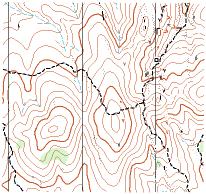
“Glenluce” – near Castlemaine, first used for the 2002 World Masters Games Orienteering Championships. Spur-gully terrain with some mining detail.
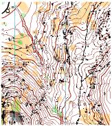
“Creswick Diggings” – Complex MTBO track networks.
“Mt Beckworth” – Complex granite features on a demanding ridgeline. The 2006 Vic Long-Distance FootO Champs were held here, and the 2008 Eureka Challenge NOL Badge event.

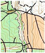
“Victoria Park” 1:7,500 scale – parkland just south of Sturt Street in the city of Ballarat. Flat and open street/parkland terrain.
Eureka Map Library Catalogue
Digital Maps – Ian Chennell – Click Here to email.
Digital Map Library Online (registered users only) – Email the Eureka Webmaster for the password, then click Here to access the library.
The club also has a stock of older paper maps, which are maintained by Heather and Richard Bice.
Current as of 17 June 2013
Paper Map Library Catalogue - Revised January 2009, Heather and Richard BiceDigital Map Library Catalogue - Revised June 2013, Ian Chennell
| Map Name | Location | Year | Quantity |
|---|---|---|---|
Foot O Maps - Paper |
|||
| Blowhole | Daylesford | 1999 | 580 |
| Buninyong | Union Jack | 1994 | 500 |
| Canadian | 1976, 1984 | 2 | |
| Canadian Forest | 1990 | 250 | |
| Canadian North | 2005 | 1 | |
| Chinaman Flat | Linton | 1995 | 600 |
| Chinaman Flat | Linton | A4, 2001 | 200 |
| Don't Wake Em Gully | 2001 | 1 | |
| Glenluce South | 2002 (World Masters) | 640 | |
| Kurucaruc Creek | 1979 | 100 | |
| Kurucaruc | Contour Only | 40 | |
| Mt Beckworth | 1990 | 300 | |
| Mt Doran | 1991 | 1100 | |
| Mt Helen | 1987 | 27 | |
| Nerrina - Nuggetty Gully | 2007 | 1 | |
| Petticoat Gully | 1994 | 50 | |
| Springdallah | 1987 | 80 | |
| Slaty Creek | 1984 | Used Maps Only | |
| Union Jack | 1984 | 100 | |
| Victoria Park | 1983 | 7 | |
| Victoria Park | 1987 | 20 | |
| Victoria Park | 2006 (Deaflympics) | 350 | |
| White Swan / Nerrina | 1994 | 100 + Cut Maps | |
| White Swan / Nerrina | 1999 | 350 | |
| Yarrowee Pines | 10 | ||
MTBO Maps - Paper |
|||
| Bull Gully Wells | Maryborough | 2006 | 9 |
| Creswick Forest | 2005 | 54 | |
| Mosquito Flat | Maryborough | 2006 | 7 |
Primary School Maps - Paper (B&W) |
|||
| Alfredton (2006) | Ararat North (2006) | Bungaree (2005) | Buninyong (1984) |
| Canadian Lead (1997) | Clunes (2005) | Creswick North (2005) | Little Bendigo (2004) |
| Miners Rest (2004) | Mt Blowhard (2005) | Mt Pleasant (2005) | Yuille (2005) |
Street-O Maps - Paper(B&W) |
|||
| Ballarat North (1984) | Ballarat West (1983) | Buninyong Town (1984) | Magazine Hill (1984) |
| Map Name | Location | Scale Print Scale] | Last Updated |
Foot O Maps - Digital |
|||
| Ballarat Uni | Mt Clear | 1:4000 | 2012 |
| Blowhole / Tipperary Springs / Rodoni | Basalt / Daylesford | 1:15000 | 2006 |
| Canadian Forest | Canadian | 1:10000 [1:15000] | 2008 |
| Canadian Forest North | Canadian | 1:7500 [1:11250] A4 Portrait | 2009 |
| Canadian Forest South | Mt Clear | 1:10000 [1:15000] A4 Landscape | 2008 |
| Don't Wake 'em Gully | Daylesford / Hepburn Springs | 1:10000 | 2001 |
| Glenluce | Glenluce / Castlemaine | 1:15000 Jointly held area with Nillumbik Emus ex WMOC 2002 | 2002 |
| Glenluce North | Glenluce / Castlemaine | 1:10000 Can use with Nillumbik Emus permission | 2002 |
| Glenluce South | Glenluce / Castlemaine | 1:10000 Nillunbik Emus can use with Eureka permission | 2002 |
| Kurucaruc Creek | Enfield / Little Hard Hills | 1:10000 [1:15000] | 2013 |
| Lake Esmond | Canadian Lakes | 1:2000 | 2012 |
| Linton State Forest | Linton | 1:10000 | 2005 |
| Mt Beckworth | Mt Beckworth | 1:10000 | 2006 |
| Mt Doran | Mt Doran | 1:15000 | 2008 |
| Nerrina - White Swan | Nerrina | 1:10000 1:15000] | 2011 |
| Surface Hill | Smythesdale | 1:7500 | 2012 |
| Victoria Park | Ballarat City | 1:5000 | 2007 |
| Yuille Homestead | Sebastobol | 1:5000 | 2010 |
MTBO Maps - Digital |
|||
| Brandy Hot | Basalt | 1:25000 | 2005 |
| Bristol Hill | Maryborough | 1:5000 | 2012 |
| Canadian Forest | Canadian | 1:12500 | 2013 |
| Creswick Forest | Creswick | 1:20000 | 2008 |
| Lal Lal | Lal Lal / Yendon | 1:25000 | 2007 |
| Linton State Forest | Linton | 1:20000 | 2009 |
| Mosquito Flat-Bull Gully Wells | Maryborough | 1:15000 [1:20000] Joint map area with Nillumbik Emus | 2012 |
| Mt Doran | Mt Doran | 1:15000 | 2010 |
| Nerrina | Nerrina | 1:15000 | 2010 |
| Rodoni | Basalt / Daylesford | 1:25000 Joint map area with Bayside Kangaroos ex 2004 WMTBOC | 2004 |
| Sulky Track | Basalt / Daylesford | 1:20000 ex 2004 MWTBOC | 2004 |