Frequently Asked Questions and Answers
About Orienteering – Eureka Style
What is Orienteering? Orienteering is an adventure sport that was originally developed in Scandinavia in the late 1800s by a keen military officer, who wanted to combine instructing his soldiers in cross-country navigation and map-reading techniques with the need to keep them fit, and make the combination enjoyable and challenging! Orienteering evolved from that into a competitive sport in the early 1900s, but it really took off in the 1960s, as the technology for making and printing detailed colour maps became affordable and commonplace.
The sport is officially defined by the International Orienteering Federation simply as “running navigation”.
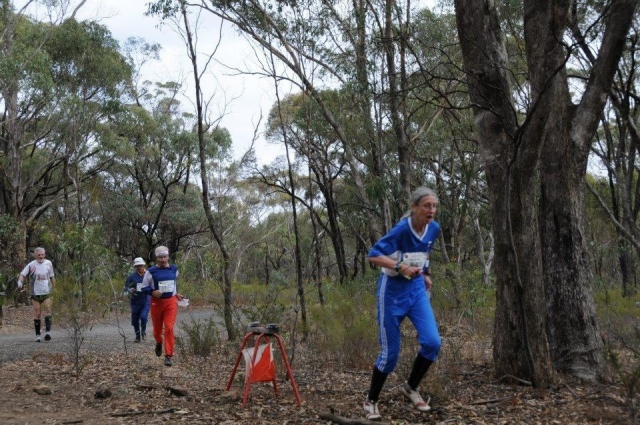
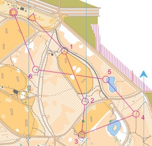
Traditionally, Orienteering involves competitors finding their way on foot around a cross-country course, using only a detailed map, a compass, and their skills and physical abilities. Likened to a car rally on foot, participants visit a set number of checkpoints, or “controls”. The start location is marked on the map by a magenta-coloured triangle. Each control is marked by a sequentially numbered magenta-coloured circle. The finish point is marked as a magenta-coloured double circle.
The control locations, and the order they are visited in, are usually decided on in secrecy before the event and marked, both on the map and in the terrain, by the course-setter. Each course is deliberately set to challenge competitors with multiple different route choice options; Do you take the shortest path up over a steep hill, or take the much longer but gentler path around? Do you follow a distinct road, track, creek or fenceline, or follow a vague ridgeline, or even follow a compass bearing directly across featureless country? Or is the next control located on one of several almost-identical rock features, among dozens of other rock features, in adjacent gullies? Straight magenta-coloured lines on the map, joining each control point to the next, are included only to aid in reading the course accurately from the map, but do not direct or influence the required route across the terrain.
For most events, the exact control locations are only revealed to each competitor at the start location where they first see the map with their course marked on it, so all competitors are equally challenged to decide on and successfully navigate their route choices while “on the clock”. The path each competitor chooses to take between each control is completely flexible, and up to the competitor to decide on-the-fly, while progressing around the course.
Most orienteering events offer multiple courses to choose from, typically from 4 to 10 options, covering a broad range of distances and degrees of physical and navigational difficulty. Competitors select which course they would like to do prior to commencing. The most difficult course offered at an event is typically between 7 and 16km long, depending on the nature of the terrain, and requires a high degree of fitness and offers complex navigational challenges. While the shortest course available might be 1 to 2km long and entirely follows bush tracks, so it is suitable for families with prams and young children learning the basics of map reading. The sport prides itself on offering “something suitable for everyone” at most events.
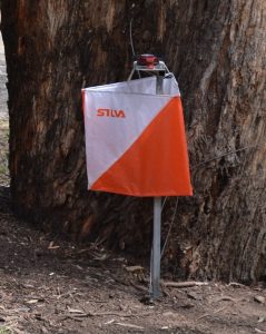
Each control point is marked in the terrain by an orange and white flag, and a manual or electronic recording device located at each control flag is used by each competitor to prove their visit to each control point.
Competitors normally participate alone, or sometimes as a small group, and the competitive challenge involves a race against the clock, with the fastest competitor around each course winning the competition. Simple events offer a few courses, while championship events are usually organised into separate age classes, for men and women. Variations on the “traditional” or “classic” orienteering format include “score” (gaining points for each control visited in a fixed period of time in any order), and “relay” events, in which teams (of usually three) race one after the other over closely-parallel courses to gain a cumulative time.
Orienteering is quite often referred to, by those involved, simply as the letter “O”! The best-known orienteering discipline is undertaken on foot, and is known as FootO, and includes subsets covering orienteering in bush/forest areas, and Park/Street orienteering which is done in urban areas. Other variations on orienteering becoming increasingly popular include Mountain Bike Orienteering (MTBO), SkiO, TrailO (which is not yet well known in Australia, but caters especially for disabled athletes), and two other closely-associated activities called Rogaining (see the Victorian Rogaining Association website for more info) and Amateur Radio Direction Finding (see the Victorian ARDF Group website for more info).
Who can participate? Orienteering is a sport that caters for all age groups and levels of ability at most events, thus making it an ideal family sport. Multiple courses are offered at events, with course lengths and degree of navigation difficulty set to suit age and experience, ranging from under 10 to over 80, and very easy through to difficult navigation. In fact, at many events, even toddlers as young as 2 are catered for with a very short “string” course following a continuous string through the bush, with plenty of novelty controls and other activities to find and explore!
How competitive is the sport? It depends on how competitive you want to be! Each competitor seeks to achieve satisfaction in their own way. For some it is being fastest around the course; for others it is navigating to each control point precisely, or making the best possible route choices; or for others it is simply enjoying being in the bush looking at wildflowers and birds. In Eureka, our club membership ranges in age and abilities from children as young as four, to family groups who orienteer together or in friendly competition, to the young-at-heart well into their nineties, to highly-competitive elite athletes who regularly compete at international level! While most come to compete in some form, some orienteers and partners of orienteers come to just chat and enjoy the company and the bush setting, or to help out with the organisation and administration of events.
Just starting? Clubs provide newcomer instruction at every event, and most orienteers will eagerly offer advice and helpful hints. On the course in the bush, if you’re geographically embarrassed, you can ask someone to tell you where you are on the map, but it is considered poor form to ask where the next control is located, or to give away a control’s location unnecessarily. Newcomers and younger children often prefer to go around in groups. Coaching is offered at all levels – just ask someone at the Eureka tent at most events!
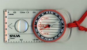
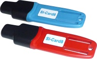
Equipment? Orienteering requires little by way of expensive equipment. To start with, comfortable clothes, and shoes with good grip for rocks and steep slopes, are a good idea. Long pants or some lower leg protection (gaiters) are recommended. Compasses can be hired at events for a small charge, borrowed from a friendly orienteer, or purchased at major events or from camping stores from $20 to $120+. Some events use an electronic timing system – in Australia this is usually the German SPORTident system – equipment for this, called an e-Card, can be hired as part of event entry, but can also be purchased for around $60 once regular participation is established. Alternately, competitors carry a cardboard “control card”, marked with numbered squares, and a small pin punch is used manually at each checkpoint to mark a pattern in the corresponding box to prove the right controls were visited in the right order. The map (and punch card if required) are provided by the organisers at the event as part of the entry fee.
Costs? Entry fees vary from event to event, but for local events expect to pay about $5.00 per map, regardless of the size of group. At state events – foot-o or mountain bike-o – the cost is from $10 to $25 for members with a $5 to $10 levy for non-members. This may sound expensive but it is cheaper than a ticket to the footy or tennis, and think of the exercise value-for-money! Consider also that orienteering is unlike many other team-based sports, where not everyone who joins a club and wants to play, actually gets selected to play. In orienteering, everyone who wants to participate does so, to their chosen extent, with an equal opportunity for success to every other participant. The entry costs mostly pay a return on the large investment made in making the detailed event map, which can require hundreds of hours of fieldwork and complex digital cartography, performed by highly-experienced orienteering mapping experts.
Getting there? You normally have to travel by car to events, but orienteers regard this as a Sunday drive with a goal. Most events are within 75 minutes drive of suburban Melbourne. Occasionally, more distant events are held, such as around Bendigo, Beechworth and Albury/Wodonga – these usually involve more than one event held across a weekend, to get the most out of the longer travel distances.
What is the VOA? OA? IOF? The Victorian Orienteering Association Inc (VOA), better known as Orienteering Victoria (OVic), is the state body responsible for the overall organisation and standards for the sport in Victoria. Although non-members may compete at any event, they are not eligible for state or national awards. Orienteering Australia (OA) is responsible for overall control of the sport in all states and territories, and carries a substantial Public Liability insurance cover on behalf of all clubs and officials. The International Orienteering Federation (IOF) is the head governing body of the sport worldwide, and is responsible for promoting orienteering in more than 70 countries on all continents around the world! The IOF also sanctions World-Ranking events for elite competitors, such as the World Orienteering Championships in the various disciplines, and is responsible for maintaining the international technical rules for competition and mapping.
Is this an international sport? Yes. There are World Orienteering Championships (WOC) held in all four disciplines of orienteering [footo, mtbo, skio and trailo (for the disabled)], either annually or biannually. Orienteering is also a member sport at the World Masters Games. Maps are drawn to an international standard that is language independent, and control descriptions are given in international symbols that are the same around the world. For the youngest age groups and easy courses, the control descriptions are also provided in plain English.
Are there separate events for males and females? No. At every event, several courses are set, and competitors nominally enter the course best matched to their age class, gender and ability. However, competitors are free to choose to run any course they wish providing they have sufficient experience. Results are sorted into age and gender so you can compare your performance with your peers. Unlike many sports where competition at a particular level requires passing through an extensive qualification process and previous proven performance, orienteering is unique in that any competitor is welcome, within the limits of experience, fitness and fairness, to compete against any other competitor, at any level of proficiency, at most events. It is only at the elite levels of competition that preselection and qualification become mandatory.
The social side? After completing your course you will find that many orienteers are keen to gather and compare their courses, commenting on their route choices and errors, and hoping not to repeat them next time. It is a friendly time and one the whole family can join in. Family or club picnics usually finish the day. Clubs also organise other occasional social events for their members. Orienteering is a truly international sport for all ages, that people can participate in at home, interstate or abroad. Whenever or wherever you participate, you will find the same friendly atmosphere.
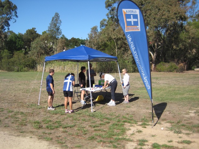
Essential knowledge for First Timers? At your first event, park as directed, then locate Event Registration, which is usually in a tent in the middle of the event assembly area or “arena”. This is where you get information on the event and the various courses on offer. Once you’ve chosen a course to do, complete a registration card, then pay your entry fee to Registration, and they will direct you to where the Start location is. This is often a short walk through the bush, following a marked path. At the Start, an official will help you through the starting process, where you’ll get the map for your course, or mark up a blank map with your course yourself before you begin, and also get the control descriptions (or “clue sheet”) that describes all the control points you need to visit and their identifying flag numbers. Finally, you will be counted down on the event clock, to start your course at a specific clock time, or at smaller events, you will probably just start yourself when you are all ready to go. On the map, the course you have to navigate is marked in a magenta or red colour, that doesn’t match any of the other map symbols. The location of the Start is always marked with a triangle symbol, so find this on the map first! Each control point you have to visit is marked with a numbered circle on the map, and by a numbered orange and white flag in the bush. For most events, you need to visit all the control points, without missing any, and strictly in the order shown on the map – 1, then 2, 3, 4, etc. A straight line joins each control point to the next one on the map, but this is a visual aid only to following the control order. Each navigation segment between one control point and the next is called a “leg”. Using your map and compass, and your wits and navigation skills, you are free to navigate each leg following any route you choose, and this is the fun and skill of Orienteering – finding the fastest, smartest or easiest way around for yourself. Often the fastest runners are not the winners on the day, and it is also unwise to follow any other competitors, as you don’t know what course they are doing, or what control they are up to! At each control point, you will need to write down a letter, punch a control card, or place an electronic stick into a recording device, to prove that you visited. Be careful – there will be other control points in the area that are not on your course, so always check the code number on each flag against your control descriptions, to make sure you’ve found the right ones! The Finish point is marked with a double circle. Always visit the Finish point and check in with the event officials, so they know you’re back, even if you don’t successfully complete your course. This will prevent safety concerns at the end of the day; if you are unfortunately injured out on the course, the organisers will come searching for you. At the Finish, your time on the course will be calculated, and the organisers will check that you visited all the control points in the right order. Your result will be placed on a results display, so you can see how you went against other people on your course, or in your age class. You will also get to keep your map and a printout from the electronic timing system. Discussing your course and route choice decisions with others is a great way to learn and share the experience. The most common phrase heard around the results board is always “How did you go?” Best of luck! 🙂
Map Reading Essentials? In essence, a map is a pictorial representation of a portion of the earth’s surface. Maps are usually drawn “to scale”, which means that any distance measured on the map represents a corresponding distance measured in the real world, and is the same in any direction. The scale is shown on the map somewhere as a ratio, eg 1:10 000, which means that 1 unit of distance on the map equates to 10 000 of the same units in the terrain; so 1 centimetre of map distance equates to 10 000 centimetres, which is 100 metres, on the ground. Orienteering maps range from 1:2 000 for very small areas like a school yard (1cm on the map = 20m on the ground), up to 1:25 000 (1cm on the map = 250m on the ground, or 4cm = 1km) for MTBO maps covering several square kilometres of terrain. Foot orienteering maps are typically drawn at 1:15 000 (1cm = 150m) as the international standard FootO scale. Sometimes 1:15 000 maps are printed at
1:10 000 or even smaller, if the area is very complex, to make the map detail easier to read.
What Are All The Symbols? Orienteering maps worldwide use a standard set of symbols to represent objects in the terrain. The colours are meaningful; earth features are mostly brown, vegetation features are green or yellow, rock and man-made features are black, water features are blue. The start, finish, control locations, and other on-the-day information like drinking water points, fence crossing points, and out-of-bounds areas, are magenta/purple.
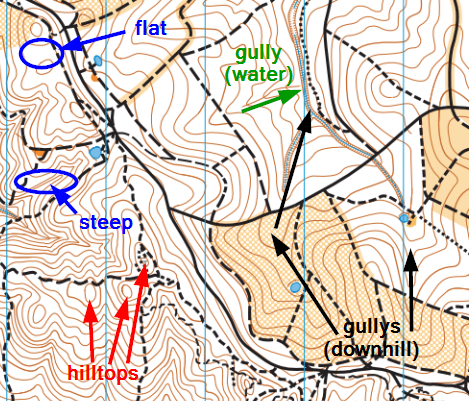 Contours 101? The shape of the terrain, hills and valleys, are shown by contour lines, which are brown. Many orienteers find contour lines tricky, and they can take a bit of practice to learn and interpret. One way to imagine contours is like a water line in a flood. If the sea level rose to flood the land, then each contour line on the map represents where the water line on the land would be, for different depths of flooding. The vertical difference in height (or water depth!) between adjacent contour lines is called the “contour interval”, and this is shown on the map, usually near the scale. Most orienteering maps use 5 metres. A couple of rules of thumb with contours: contour lines close together represent steep terrain, contour lines far apart represent level, flat areas. Closed circular contours represent hilltops. The locations of streams and rivers (in blue) help greatly to identify which terrain is “up” versus “down”. Moving along or parallel to a contour line on the ground involves staying level, neither climbing nor descending. Moving across contour lines always involves either climbing or descending.
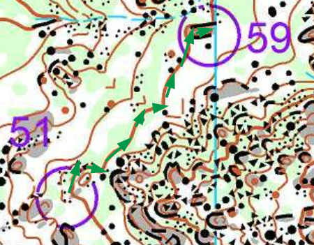 Techniques? One navigation technique, called “contouring”, involves using the contour lines to help navigate, by concentrating on neither climbing nor descending as you move around a hillside. An example of a leg using the contouring technique in complex terrain is shown here; by “following” the thick brown contour line from 51 to 59, concentrating on staying at the same height around the hillside, it is safer to navigate when compared to interpreting the detailed rock formations and risking losing awareness of your location in the complexity.
Other useful techniques include:
- attack points – using prominent, easy to find point features, such as a track junction or a hilltop, to precisely navigate from to find checkpoints on smaller or more vague objects.
- aiming off – deliberately aiming left or right of a control, such as on a crossing stream or track, so you know which way to turn along the feature to find the checkpoint.
- catching features – identifying a line feature beyond the control location, so you’ll quickly know if you’ve overshot the control.
- handrails – using long line features, like roads, fences, ridgelines, or gullies, to help navigate longer distances quickly.
- traffic lights – dividing each leg into smaller segments requiring different levels of concentration – green (run fast), yellow (pay attention to the map), and red (slow, fine, accurate navigation).
- running on the needle – using the compass to follow a straight line bearing through the terrain.
- thumbing the map – using your thumb to mark your exact location on the map.
- pace counting – counting your steps, and using your previously-measured pace length to roughly calculate distances.
- relocating – being able to recognise that you don’t know your exact location, and then use map reading to re-find your location on the map, and/or get to a suitable attack point to restart accurate navigating. In orienteering, we rarely say that we are truly “lost”! Instead, we say we have “lost contact with the map”, and then take steps to relocate ourselves and regain contact, to enable accurate navigation to resume.
Which Way Is North? On orienteering maps, the map area is usually covered in parallel blue lines which point to Magnetic North, and which way is North will be clearly indicated. If you are familiar with magnetic declination between True and Magnetic North and the arithmetic for converting bearings, you don’t need to worry about this while orienteering – we are all about navigation, not mathematics! The sport always maps only with Magnetic North to be compatible with magnetic compasses without needing to convert anything. While orienteering, it is important to ensure that your map is always “oriented” correctly to match the real world, so Magnetic North on the map is kept pointing towards Magnetic North on the ground. That’s where carrying a compass comes in very handy! As a beginner, get into the habit from the outset of placing your compass flat on your map, then turning the map around so that the Magnetic North lines align with the Magnetic North (red) end of the compass needle, before interpreting the map to find direction.
Want to Know More? Further information on Orienteering can be found at the Orienteering Australia website by clicking on: http://orienteering.asn.au/index.php/get-involved/.