Hi all,
At the planning meeting yesterday at the Prendergast’s, we decided that Eureka should adopt the Maprun smartphone application to conduct the next series of BUNS.
So, before reading on, grab your smartphone and install the Maprun app from the Apple Store or Google Play! You will be asked to enter your basic personal details when you first run the app.
With that in mind, we’ve also decided to change the name of the next series to the “Ballarat Map Run”, which we feel is easier for new participants to understand readily than “BUNS”, which we almost always had to explain…
Before we start doing Maprun events with publicity in place, we decided to use one of our past BUNS events as a test Maprun event, to prove we can get it working before adding the pressure of a live calendar and new participants.
Last night, I took a couple of hours to work through Peter Effeney’s excellent instructions about setting up an event, and sent him the required files for last year’s event I set at Don Lead. Only a handful of people made it to that one, as many of the usual attendees were away in Europe at the time. It was a very gusty morning as well, and not very pleasant.
Very pleased to say that setting up a Maprun event is fairly straightforward, using Google Earth.
The test event is available now in Maprun, so anyone who wants to go and try it out, you’re very welcome to. We will be meeting at the Fidelity Club Kindergarten in Ripon Street next Sunday at 5pm to run as a group, if you want to run with company, or need help setting up Maprun on your smartphone. Otherwise, the event is open now and has no expiry date, so you can go and try it out at your convenience if you’re comfortable with using Maprun and how to start your run yourself.
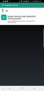
The event is called “Eureka Test Don Lead”, and it’s under the Victoria>Ballarat folder. Usually it will also appear in Events Near Me.
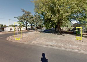
The exact Start point is the streetsign on the Northwestern corner of Ripon and Urquhart Streets. The Finish point is the southeastern fence corner of the Fidelity Club Kindergarten, about 30m north of the Start point.
Important: Once you Start the course in the app, and you’ve visited one or more checkpoints, don’t come near the Finish point until you’re ready to finish! Otherwise Maprun will end your run.
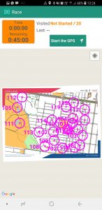
I’ve used the “Victorian Street-O Score” format in the event, so its 20 points per checkpoint, with 10 points off per minute or part of late after 45 minutes. That’s the closest one to our usual, but we can configure our own score format as well if we want to be different.
Maprun does allow you to read the map on your screen in the app. However, if you’re like me, trying to run while reading a small phone screen in bright sunlight is no fun, and a recipe for a very short run with a painful ending…! I’ve attached a PDF copy of the map to print out. Theres also a couple of screenshots to assist with setting up Maprun, and where the Start and Finish are.
Enjoy, these are exciting times, and Maprun will add a new dimension to our urban orienteering!
Regards, Ian